What you’re missing is that the path itself changes you.
Julien Smith
 |
| Gila Cliff Dwellings |
The precipitous drive to the Gila Cliff Dwellings National Monument takes longer than the actual visit of its famed Gila Cliff Dwellings. From Silver City, carefully follow 40+ miles of twisty, narrow, steep, heavily forested, mountain road that easily keeps the less passionate among us, away. After a vigorous steering and nerve workout, you’ll be happy to ultimately stretch your legs and mind at this stunning primeval location.
 |
| View from Cliff Dweller Canyon Approaching the Gila Cliff Dwellings, middle left |
The Gila Cliff Dwellings are located inside one of two supervolcano calderas that erupted 28-35 million years ago, with a force estimated at 1,000 times the power of the Mount St. Helens’ 1980 eruption, and created what today are called the Mogollon Mountains.
Five naturally eroded interlinked alcoves situated 200 feet up the northwest side of Cliff Dweller Canyon contain earlier homes of the Tularosa Mogollon People. About 42 rooms were constructed from local stone. All wooden beams (vigas) seen in the dwellings are original. Their tree-ring dates range from 1276 to 1287 CE, suggesting the dwellings were constructed in a relatively short time, perhaps in, as little as, eleven years. The Gila Cliff Dwellers departed these homes and abandoned their surrounding fields by about 1300 CE. Dire need may have sent the families elsewhere or they were simply ready for a new location.
 |
| Still a few wine-colored apples (tunas) left on this cactus Local food for humans and animals alike |
For thousands of years, various groups of nomadic people used the caves of the Gila River as temporary shelters, but between 1260 and 1280 CE, people of the Tularosa Mogollon Culture decided it would be a good place to ‘permanently’ call home.
Based on the number of hearths
used for cooking found in the dwellings, and on an assumed number of four to five
people per household, archeologists suggest that a total population would be
between 40 and 60 people who had abandoned small pueblo settlements to take
advantage of the sheltered dry cave near a year-round spring for about only one
generation (20 years).
The Gila Cliff Dwellings housed a relatively isolated settlement, during a time of harsh climatic straits, the well-known Great Drought of 1276-1299, when cliff dwellings in other parts of the Southwest, notably the Anasazi area (i.e. Chaco Canyon Culture), offered a haven to refugees in similar circumstances.
The duration of occupation of
the Gila Cliff Dwellings beyond 1287 is unknown. Evidence of a relatively short duration is
suggested by the lack of post-construction modifications. There are unfinished floors and no layered,
multi-level floors. In addition, there
is almost a total lack of room remodeling.
When the
Tularosa Mogollon People moved on, they left these walls, a few pottery shards,
and some food stashes as a glimpse into their past for us to study, interpret,
and explore today.
 |
| T-shaped doorway also found in Mexico, Ecuador, India, Peru and beyond Often encountered in Anasazi and Maya cultures Also seen in Tibetan sand mandalas |
The true meaning of T-shaped doorways is still unknown. Does it represent half of the plus ‘+’ sign, a doorway to the spiritual world, a shape making it easy to carry a large load on the shoulders without having to turn sideways? Could it just represent a person with open arms, or a symbol of life force? Overall, this T-shaped door is seen as an indication of trade, not only of goods but of ideas, beliefs, and architectural styles.
 |
| Getting closer Darkened with soot and still supported by original vigas (wood beams) |
 |
| From below, well protected from the elements Black traces of intermittent waterfall to the right |
Upon their
return, they reported that they had discovered some stone ruins in caves, the
first recorded visit to what later was to become known as the Gila Cliff
Dwellings. Six years later, in 1884, the
site was visited by Adolph Bandelier, one of the earliest anthropologists to
work in the Southwest. Looters had
already stolen many artifacts and destroyed much of the archeological record.’
Beginning in mountains just north of the dwellings, the three forks of the Gila River converge in this valley and ultimately flow toward the Colorado River. A natural spring at the head of the canyon provides a small, but constant flow of water that has sustained this lush ravine oasis for centuries. This reliable water source was probably a major factor that attracted the Tularosa Mogollon People to this canyon instead of other places.
 |
| Two-story structure thought to be wood storage below and an area for smoking/drying food above enjoying great open ventilation on either side |
One of the reasons that has
been given for the Great Abandonment is a changing climate in the
form of persistent drought. One clue
that drought might not have been a major factor is the fact that during their
stay at the Gila Cliff Dwellings the dwellers ate very well on an apparent
abundance of domestic crops.
Pottery recovered from the dwellings
is almost all Tularosa Phase, and nearly identical to the Tularosa Phase
collections reported from the Reserve, NM, area, which date from 1100-1300, corroborating
the tree ring data. Tularosa and Tularosa/Reserve Phase pottery are by far the
dominant pottery types recovered in the various archaeological excavations at
the dwellings, suggesting limited contact with other areas. However, a small amount of Classic Mimbres
Phase pottery was also found within the dwellings.
Horticulture and farming of
domesticated plants were of great importance to the Gila Cliff Dwellers. This is based on the vast diversity and sheer
volume of plant remains left behind, which included several varieties of maize
(corn), three types of squashes, and several types of common beans and tepary
beans. Of the 32 species of plant
remains found in the dwellings, 24 were wild.
These included wild grapes, berries, acorns, and piñon nuts. The large volume of corn cobs left behind was
so impressive that it often received a special mention in many of the early
studies and reports and goes against the idea that the dwellers left due to
lack of crops.
In the past fifteen years
there has been a persistent highly, and often times hotly, debated line of research
that indicated that the time period of 1150 to 1300 was marked with significant
societal collapse and warfare in the Ancestral Pueblo/Mogollon world. The evidence is in the form of retreat of
villages to more defendable sites such as cliff dwellings and craggy mesa tops,
plus the
discovery of large-scale
massacres, mutilation of bodies, and even cannibalism at various site
throughout the Southwest. Review of this
evidence, however, can certainly lead one to the plausible speculation that the
Gila Cliff Dwellers lived in their caves for reasons of safety.
Apparently bad things were
happening in the Ancestral Pueblo/Mogollon world, and as a result large groups
of people were migrating away from the troubles to safer places. Were the Gila Cliff Dwellings such a place,
if only a temporary one in their migration away from these 13th century
troubles up North? There is absolutely no
indication that the Gila Cliff Dwellings were ever attacked.
Convincing evidence supports
the argument that the Gila Cliff Dwellers were Chacoan Nobles. Primary evidence for this fact is the profusion
of prestige-economy marine shell jewelry, 26 macaw feathers, and one macaw
skull; plus the architectural evidence in the commanding presence of a T-shaped
door that for all intents and purposes says, ‘We are Chacoan’. If they were Nobles, then the evidence from
Chaco also strongly suggest that they probably did not build the dwellings,
farm the fields nearby, gather wild edible plants, or cook their own meals. Chacoan Nobles didn’t do such things; they
had commoners or slaves to do this work.
The Mogollon People didn’t
disappear. The descendants of the Puebloans
of the Mogollon Area who built these cliff dwellings belonged to a larger
tradition that included part of what is now Arizona, New Mexico, Texas and
northern Mexico.
Evidence suggest that the
Apache migrated to the upper Gila River in the 1500’s, though some of their
oral traditions say that it has always been their homeland. Legendary leader Geronimo (Goyahkla) was born
near the Gila River headwaters in the early 1820’s, when Mexico challenged
Apache control of the region. Thirty
years later, the US asserted its authority in the area. It built army posts, and by 1870 the federal
government began to relocate the Apache to reservations. But not until September 1886 were the last
‘Be-don-ko-he’ as Geronimo’s people were known, forced from their ancestral
lands, led by Geronimo himself.
They were shipped in boxcars
to Florida as prisoners of war. Suffering
the ultimate betrayal, they were not allowed to see their families as agreed in
their terms of surrender. Thus ended the
freedom of the Chiricahua Apache (Ndé People) in their traditional
territory. They became the LONGEST
held prisoners of war in US history – 27 long years! This experience has
defined the Ndé identity as one of adaptation to any environment.
A very sad history envelopes this area but its beauty remains.
 |
| View of the Catwalk Trail from above Unfortunately, the river is very low at this time of the year |
The name for this area refers to the original 1890’s plank-board walkway placed atop the steel pipe that used to bring water to the electric generator of the ore processing plant and to meet the needs of the 200 towns-people. Three miles of pipe linked the town and its generator to water.
The Catwalk Trail, now made of steel, only covers the first half mile. Although most of the pipe is now gone, much of the modern all-access trail follows the original route. In the mid-1930’s the Civilian Conservation Corps (CCC) rebuilt the Catwalk Trail. However, mother nature likes to remind us of her strength once in a while, and a huge flood washed away most of the system in 2012. Thankfully, it is open once again.
Suspended
about twenty feet up the canyon wall, it’s a bit like walking at tree canopy height
inside a vibrant riparian area with cascading water, transparent pools, huge
boulders, and cool green shade below. Tightly
nestled in dry and rocky desert landscape, it’s an amazing oasis.
Water gushes beneath you,
providing a steady soundtrack as it flows around huge boulders and picks up
speed inside this very narrow gorge.
 |
| Just imagine what it would look like if the river were high |
Mogollon Ghost Town
After
driving additional winding narrow switchbacks, seemingly common in this area, I
finally and gently coast down into the ghost town of Mogollon. This place is slowly rebuilding after being devastated
by several fires and floods over the years.
In its heydays, between 1876 and 1942, it had up to 6,000 residents
(ranchers, farmers, traders, claim jumpers, gamblers, stagecoach robbers, miners,
etc.), now only 12-15 people call it home part-time or full-time. Silver and
gold were extracted here, producing up to 70-75% of New Mexico’s precious
metals at the time. Up in these
mountains, it is difficult to fathom that many lived in tents or were cave
dwellers (lots of caves around these canyons), especially during the very wet
springs and long cold winters.
 |
| False front on older house |
Over 600 miles of tunnels were blasted or chipped away in 7-8 mines. By the end of the first year they had already reached one million dollars in payroll alone!
To get here, you followed the very winding dirt Bursum Road (built by convict labor in 1897), now paved state road 159. As you drive into the narrow walls of Silver Creek Canyon and into Mogollon, you feel like you’ve entered a time capsule where a chapter in the history of the American West has been preserved.
Silver City was the railhead for Mogollon's eight-team freight wagons, packed with gold and silver ore. The drivers showed great ingenuity in harnessing and driving the wagons, often with 18 horses pulling them (or slowing them down) around tricky mountain hairpin curves.
The dirt road rises 2,000 feet in a distance of about
seven miles before dropping back down about 1,200 feet to Mogollon. It has
solid rock straight up one side for hundreds of feet and straight down an equal
or greater distance on the other side, not for the faint of heart.
 |
| Built for the 1973 movie 'My name is nobody' with Henry Fonda Fake 'old' General Store |
 |
| Mailboxes on front deck, interesting location |
His
discovery occurred sometime between 1870 and the fall of 1872, during the time
of the Apache Wars. Cooney could not immediately pursue his discovery, as he
was still committed to duties with the army. But he kept this secret with him, and in 1876, he returned to
Mineral Creek Canyon to file claims along with his business partner, Harry
McAllister.
 |
| A door to nowhere. Old dynamite depot? |
 |
| Tarnished but full of stories |
The Silver City and Mogollon Stage Coach provided transportation and freight services to the camp, moving its ‘cargo’ some eighty miles between the two points, a distance that took 14-15 hours then, and a bit over an hour today.
The Mogollon mines were located on precipitous slopes and ridges, including the Maud S, Deep Down, Confidence, Last Chance, and the biggest and most profitable, the Little Fannie. In 1909, the proud miners related that nearly 70% of the precious metal of New Mexico was produced by the mines of Mogollon amounting to $5,500,000. Over the years, Mogollon Mines produced nearly twenty million dollars in gold and silver (or $400M in today’s dollars).
With its mines silent, Mogollon officially became a
ghost town, but some of its owners remained.
Today, it is a ghost towner’s dream as nearly 100 historic buildings
remains. The entire town was placed on
the National Register of Historic Places in 1987.
 |
| JP Holland General Store converted into the Silver Creek Inn |
The town’s original ‘jail’, was a cottonwood tree: … the culprit was chained to it for a misdemeanor and hung from it for a felony.
The ghost town of
Mogollon is eerily secluded in the slim Silver Creek Canyon on the western edge
of the Mogollon Mountains in the vast Gila Wilderness. Well worth a visit if you feel like being
back in time.
 |
| Circle of oak trees at campsite, are there druids nearby? Autumnal colors |
San Lorenzo Canyon: Chihuahua Desert
 |
| Angular unconformity just before entering the canyon |
An angular unconformity is a small, isolated mesa looking much like a tilted, sliced loaf of bread with a cap on top. The slanted beds of sand and mudstone are about 7-10 million years old and the horizontal cap is about ½ million years old. These drainage channels (lines) changed angle when moving plates deep beneath the surface tilted the plain.
The 200-foot-high cliffs along San Lorenzo
Canyon were cut by stream erosion during the last 200,000 years.
 |
| From 7-10 million (bottom) to 1/2 million years old (top) |
All the faults that cross the San Lorenzo Canyon
are normal faults of the Rio Grande Gorge Rift.
(see previous post on world rifts).
 |
| Beautiful curvy rocks |
 |
| Some shade while biking the canyon |
Named after the first person to discover cosmic radio waves emanating from the Milky Way in 1931, and considered founding figure of radio astronomy.
 |
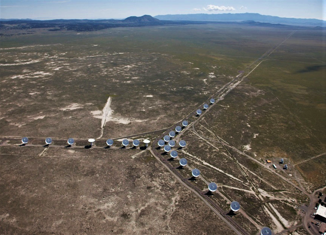
| Massive radio dishes in the New Mexico high desert |
Cosmic radio waves are billions of a billion times fainter than radio waves used to broadcast information on Earth. Radio telescopes must be placed where they can collect these faint cosmic radio waves without any radio interference from humans or nature. (cellphones need to be turned off when visiting).
The Plains of San Agustin in New Mexico, northwest of Socorro, is a flat stretch of desert far from major cities. The Plains are ringed by mountains, which act like a natural fortress of rock that keeps out much of the radio interference from cities even hundreds of miles away.
The desert climate of
the Plains of San Agustin is critical to the success of the VLA. Humidity is a
real problem in radio astronomy because water molecules distort the radio waves
passing through them and also give off their own radio waves that interfere
with observations at certain frequencies. Radio telescopes that collect radio
waves in the same frequencies as water’s radio waves need to be in deserts to
reduce this background signal from Earth-based water molecules.
What you see spread before you
is an assemblage of huge radio dishes, 27 of them, to be exact. They may all be
clustered together in the center of what was once an ancient sea, or they may
be spread out along their connecting railroad tracks to a span of 26 miles
across the Plains of San Agustin. If you pause to watch them, you’ll see the
dishes rotate and move simultaneously as they search the sky for the focus of
the current object of research.
 |
| From the VLA website, sky view of the 'Y' tracking configuration |
The dishes are 95-feet tall, 230-ton, and 82 feet in diameter. They travel on 13 miles of train tracks in the shape of a ‘Y’. There are nine dishes on each arm of the ‘Y’ with one spare for maintenance/repair replacement. In essence, the array acts as a single antenna with a variable diameter. The antennas are moved every three to four months with a special tractor called a transporter. There are five main configurations A, B, C, D, and BnA, varying in sizes.
Astronomers using the VLA have
made key observations of galaxies, black holes, supernovas and protoplanetary
disks around young stars, discovered magnetic filaments and traced complex gas
motions at the Milky Way's center, probed the Universe's cosmological
parameters, and provided new knowledge about the physical mechanisms that
produce radio emission and allowing investigations of many astronomical objects.
 |
| You can see some of the dishes from the highway The VLA was closed due to Covid-19 |
The VLA has been used by more astronomers and has been mentioned in more scientific papers than any other radio telescope in the world.
 |
| VLA at night, by Alan Osterholtz, New Mexico |
‘An elusive essence is
more than the sum of a community’s parts, its people and its past, but
reflecting all of these elements is what makes a personality of a place.
Southwest New Mexico has an undeniable personality from its ruggedly beautiful
landscape, echoes of vanished cultures and a continuing, complex human
heritage. It is a richly textured living collage, with a uniqueness only found
in rural areas that are historically multi-cultural.
There are several
historic layers, some scarred by conflict, others enhanced through
collaboration, each contributing something to the area today. The region’s deep
Hispanic and Native American roots are reflected in the distinctive foods,
architecture, family ties and community celebrations.’
I couldn’t have said it any better. Hope you enjoyed my last 2020 trip. More to come, hopefully, in 2021.
Fantastic trip to end 2020!! You pack a LOT of interesting aspects into each article! Thank you so much!!
ReplyDelete