The true mystery of the world is the visible, not the invisible.
Oscar Wilde
 |
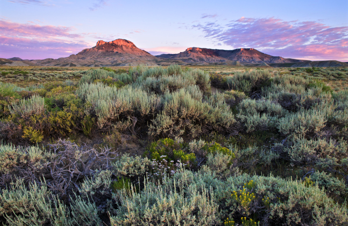
View
of the McPhee Reservoir from the Escalante Pueblo site |
Both Hovenweep and Canyons of the Ancients National Monument preserves thousands of Ancestral Puebloan artifacts. The two monuments overlap, with a few portions of Hovenweep forming enclaves within Canyons of the Ancients. Canyons of the Ancients is not as well developed. It is much more of a ‘choose your own adventure’ kind of opportunity. There are fewer established amenities to help direct visitors. Rather, you are left to the devices of maps, road signs, and your own common sense to guide yourself to excavated pueblos or other treasures.
Located in the Great Sage Plain the Canyons of the Ancients Visitor Center and Museum is a federal research center, curation facility, and museum with approximately three million records, samples, and artifacts from public lands throughout southwestern Colorado.
It began raining gently just as arrived but, in the distance a major storm was brewing, so I walked quickly to get a glimpse of the McPhee Reservoir from the Escalante Pueblo before getting soaked. The high desert smell of rain, and the odors of sage, juniper, and piñon fragranced the air. It was heavenly and calming despite the approaching downpour.
Lowry Pueblo in Canyons
of the Ancients
 |
Lowry
Pueblo, partly covered for preservation |
Changing floor plans show record growth stages in this pueblo. The first kiva and four-room core expanded to a 40-room building in about one generation (1085-1105 CE). Archeologists envisioned ‘frenzied and exuberant outbursts’ of demolition, remodeling, and new construction that often erased evidence of earlier layouts. Lowry Pueblo does not represent a homogenous unit built at once. It was added to and modified six or seven times at least.
 |
Various
stages of constructions, sign near the actual site |
Several years ago, while
looking at the Great Kiva in its final, and current, 30-foot diameter layout, a
visitor from the Santa Clara Pueblo interpreted the unique stone features (slightly
resembling Kokopelli) on the floor of this Great Kiva as symbols of
winter people and summer people – a Great Kiva feature not seen
anywhere else.
 |
The
Great Kiva at Lowry Pueblo is considered one of the northernmost |
Tree-ring dates indicate that this Great Kiva was a relatively early building at Lowry Pueblo. It was remodeled many times and used continuously by every successive generation. This Great Kiva was the ‘drawing card’ which caused people to settle again and again at this site.
 |
Not
sure which is winter and which is summer |
Summer and Winter People
They were and are those who supervise activities of summertime or wintertime. Contemporary Pueblo People continue to be organized on a clan basis for pueblo activities and rituals. The clans of the eastern Pueblos are organized into Summer people and Winter people. The western Puebloans are organized into several matrilineal lineages and clans.
In times past, each village was divided into these two sections, the Winter and Summer people, and the Chief of each village would alternate between the two groups depending upon the season. According to Bandelier, ‘The dignity of chief penitent or cacique belongs alternately to each of these two groups. Thus the Summer cacique serves from the vernal equinox to the autumnal, and the Winter cacique from the autumnal to the vernal equinox. On very important occasions, however, the Winter cacique is inferior to his colleague.’
The functions of the two caciques are mainly hierarchical. They are two moieties, which are purely ceremonial in function. The Squash People are identified with the summer season, and in local parlance are generally known as the Summer people. The Turquoise People are identified with the winter season, hence are generally called the Winter people.
Every child belongs automatically to the ceremonial moiety of its father. Each moiety has a kiva. Summer/Squash kiva is in the southeast quarter of the pueblo and Winter/Turquoise kiva is in the northeast quarter. Formerly the moieties were known as South People and North People.
 |
| Hopi blue cornmeal/corn |
In ceremonies the Summer cacique is usually addressed as ‘my old woman’ and the Winter cacique as ‘my old man.’ Both hold their positions for life. It is the duty of the caciques to see that the numerous ceremonials are maintained in unbroken sequence. Specifically, the Summer cacique prays for rain and growing crops, employing in his rituals meal made of blue corn, symbolic of the blue summer sky; the Winter cacique prays for snow and fertile seeds, using meal of white corn, symbolic of snow-covered fields.
The Summer society is said to have been the first society established. It is held in very high esteem, for its function is to pray for rain, for the growth of cultivated and wild products, and for the good of the entire world regardless of tribe or race. Disaster would inevitably follow a lapse of attention to this duty. The Winter society performs a similar service in its season of the year.
The above is an excerpt from: The Tewa: San Juan from The North American Indian Volume 17 (www.worldwisdom.com)
Moving On Leaving High Density of Artifacts Behind
If you ask any modern Puebloan Groups, the descendants of these ancient villages, they will tell you that their sites were not abandoned out of strife. Instead, people left because it was simply their time. They were on a migration to find a permanent place to call home, and their time had come to an end. Themes of migration are common in Puebloan lore and storytelling. Today’s Puebloan People, be that the Hopi, Zuni, or others, maintain that their ancestors were simply following patterns of migration on their great journey.
As well as having an excellent museum, Canyons of the Ancients National Monument boasts more than 100 archeological sites per square mile! As the weather was changing and there were high chances of flashfloods, I only had a brief chance to visit the Lowry Pueblo on my way to Hovenweep. Driving through parts of Canyons of the Ancients felt like following a trail from the past to better understand the future, or from adventure to understanding. It provides a genuine looking glass into the region’s rich history.
It was the most densely settled region of the Ancestral Pueblo People world between 500 and 1300 CE. More than just islands of architecture, these ancient places existed as single-family farms and field houses, checkdams, reservoirs, great kivas, cliff dwellings, shrines, sacred springs, ancient roads, villages, clay sources, kilns, stone quarries, hunting stations, agricultural fields, rock paintings, petroglyphs, and towers.
Once seen, it is hard to forget this intriguing area. One returns home with intense memories of impressive sandstone panoramas carved by wind and water into shapes of every kind, a true geologic spectacle accompanied by tricky and intricate plant and animal life.
Great Sage Plain
 |
Grey
shrubs – perfect for hiding birds and small mammals from preying hawks. |
I am traversing part of the Great Sage Plain, a high, arid plateau dominated by intoxicatingly fragrant sage. It lies between the Abajo Mountains in southeastern Utah and the San Juans in southwestern Colorado, mostly at an elevation ranging from about 5,500 feet to 6,500 feet above sea level. As I drive, I wonder if the name could mean an area full of wise (sage) ancestral people as well as an area full of sagebrush (sage).
The Canyons of the Ancients National Monument contains more than 8,300 documented ancient sites and an estimated 30,000 total sites including villages, kivas, rock art, dams, reservoirs, field houses, and even multi-room dwellings. The remnants left behind give a glimpse into the lives of the native people, from their shrines to agricultural fields, and from sweat lodges to mesmerizing petroglyphs.
This is a place of microclimates within climates. The land plunges from treeless, tundra-swathed peaks down through alpine forests, across juniper, piñon, and sage-covered mesas and ends in treeless grasslands in the lower basin floor. Annual rainfall ranges from more than 40 inches in the mountains to six inches in the basins.
Ian Thompson
The Bureau of Land Management (instead of the National Park Service) is responsible for the protection of all the cultural resource sites in this area. Stretching along an arc of southeastern Utah into southwestern Colorado, the Great Sage Plain contains the highest density of prehistoric and historic sites in North America. It is thought that upwards of 30,000 people lived here in the 1200’s.
We are told by tribal consultants that pottery sherds that seem scattered across this landscape were left behind on purpose so descendants could identify their homes and fields when they returned. Rock art, too, was left behind to connect their descendants with the events, important people and resources of their songs and stories. Symbols like the spiral, seen on cliffs and pueblos throughout the Canyons of the Ancients, are associated with ancestral migrations and were left in places during the ancestors’ journey to their destined home.
Sagebrush is one of the most common shrubs in the high desert of the southwest. Preferring dry, rocky areas, big sagebrush grows in elevations up to 7,500 feet. Homesteaders learned that big sagebrush grew noticeably taller where soils were deeper and selected their farm sites where the sagebrush grew tallest. Native farmers likely used this marker to their advantage as well.
When the Ancestral Puebloans depleted juniper as a fuelwood, they often burned shrubs like sagebrush. Piñon was more important as a food source and therefore was not a preferred fuel. Many archeological excavations show shrubs as the last wood burned in prehistoric hearths.
Canyons of the Ancients Visitor Center and Museum
The
yucca-fiber sandals of Ancestral Puebloans, the leather sandals of Franciscan
priests, leather Ute moccasins, work boots of ranchers and lumberman, the
rubber tires of wheelchairs, and the nylon and leather shoes of visitors today
have traveled the landscape of southwest Colorado. From the earliest hunters and gatherers to
recent urban escapees, families and loners have come to take advantage of the
diverse resources: water, farmland, timber ranch land, mineral riches and
recreation opportunities.
From sign outside the museum
 |
Escalante
Pueblo behind the museum and above McPhee Reservoir |
Escalante Pueblo at the top of the hill behind the museum, built around 1120 CE. It shows the changing needs of the people who lived here. Just like today, a new baby, a room for the in-laws or aging parents, or the need for more storage space were likely reasons for various remodels.
At the ruin, there is, as is the case at many of these sites, a sense of tranquility which I cannot explain. This cluster of mounds seems to gather the surroundings landscape around itself in such a way as to become the center of that circle of earth and stone, forest and field.
Ian Thompson
McPhee Reservoir
In the 1980’s a dam
turned ten miles of the Dolores River into the McPhee Reservoir. The reservoir covered a very rich slice of
history, hiding all evidence underwater.
Before the waters rose, historical and archeological research projects
created a record for future generations.
Canyons of the Ancients Museum (formerly Anasazi Heritage Center):
 |
Striped
shoe-sock, made of cotton and animal hair |
 |
Bundle
of spun cotton yarn wrapped |
 |
Replica
of split twig figurine |
Split twig figurines dated 2900-1250 BCE are from 30 sites in Arizona, Utah, Nevada, and California. Each is made from a single split and bent willow branch. Many were recovered in the debris of daily living – discarded ash, broken tools, food scraps, etc. These may represent totems, animal relatives of the people who made them.
At other sites they were
found ritually cached in pits or beneath rock cairns. These often contained bits of animal dung, or
were pierced by tiny spears, apparently as hunting magic.
 |
Oldest
coiled basket found in the Americas |
 |
Indian
Ricegrass (Achnatherum Hymenoides) |
Indian ricegrass is one of the more widely adapted native grasses of the nearby rangelands. It is drought tolerant and grows at elevations between 3,000 and 10,000 feet. Seeds are high in protein, and members of various Indian tribes used them to make flour. A day’s labor could result in about a quarter of a bushel of clean seeds.
 |
Very
small seeds of Indian ricegrass |
 |
Tied
bundles of grama grass made good hair brushes |
 |
Stone
concretions were collected for their odd shapes |
Timeline and Terminology
Paleoindians
The first people in the Southwest hunted large game such as mammoth, camel, horse, and giant bison in a cool, moist landscape. The Clovis people were here about 13,500 years ago. But others may have arrived thousands of years earlier. This truly ancient time is difficult to study; fiber, leather and wooden artifacts disintegrated long ago. Stones and bones are deeply buried unless erosion uncovers them by chance. The earliest campsites may be underwater along now-submerged coastlines of the last Ice Age.
Basketmaker I
It never existed! When archeologists coined these terms in 1927, they expected eventually to discover an ‘original’ Basketmaker I phase. Now we know the Archaic lifestyle (7000-1000 BCE) directly preceded Basketmaker II.
Basketmaker II
The Basketmakers did not invent baskets – but they made beautiful large ones, along with elaborate sandals and multi-colored rock art. Basketmakers were the first to plant corn and squash and to depend on the harvest, which changed their lifestyle. They learned to balance hunting and gathering (which requires mobility) with agriculture (which limits mobility).
Basketmaker III
Pit structures grew in
size and depth, beans were added to farm crops, and settlements grew as
families clustered around communal structures and stone-lined storage
pits. People began to make pottery
(better than basketry for cooking or storing food) and adopted the bow and
arrow.
Pueblo I
A mild climate (750-900 CE) allowed crops to flourish at a range of elevations. Dispersed families gradually drew together near central villages. They domesticated turkeys and stored excess food for lean times. Pueblo I settlements included rows of storage rooms made of sticks and clay, known as jacal construction. These rooms also served as kitchens and bedrooms during warm weather. Pit structures became deeper, with roofs closer to ground level. Some communities built large pit structures for public events. The Pueblo I period saw rising populations and large villages in the Dolores area, followed by a sharp decline after 900 CE.
Pueblo II
Cold snap in the 900’s pushed most communities toward warmer land to the south and west. After several generations they returned in larger numbers than before. Some villages resembled the old pattern. But others were two or three stories tall, with community buildings and public spaces. After about 1100 CE, pit structures were built fully underground or within multi-level room blocks. Builders mostly abandoned jacal in favor of stone masonry. Pottery and architecture design from Chaco Canyon influenced many Four Corners Settlements.
Pueblo III
In a century of rapid
change, most people moved from dispersed family farmstead into compact
villages. The overall population
declined, but the remaining pueblos grew larger than ever before. A scarcity of resources such as firewood,
game, water, or arable land probably led to competition and conflict between
communities. Belts of empty land now
separated one group’s hunting / gathering or farming territory from the next. The new settlements had defensible locations:
some were built inside rock alcoves, others within walled compounds around
canyon-head springs. In most cases the
new villages were closer to water sources than to ideal farmland.
 |
Map
of the many theories of |
They understood that humans are not distinct, separate beings from the natural environment but that every act and thought of any human being affects the cosmos. They moved through the land with a sensibility that allowed nuances of the wind, sun and ground to affect their decision making… Their sense of home, or place, was in the space between the earth and sky and not within a specific human-built structure.
Dr. Rina Swentzell, Santa Clara Pueblo
 |
| Colorful lichens |
Toujours aussi intéressant (et épaté qu'on ait retrouvé un panier vieux de 9000 ans)
ReplyDelete