 |
Arrowleaf
balsamroot plants on Spokane South Hill |
From Spokane, we headed west, towards the ‘desert’ territory of central Washington, but veered south before reaching it, ponderosa trees gradually receding, making place for diversely colored crop fields akin to a gigantic farmers’ quilt displaying shades of rough brown, bright gold, muted taupe, and lively green. When European farmers first came to the Palouse, it was thought to be too arid for farming and was considered part of the Great American Desert, until they experimented, very successfully, with dryland farming.
 |
| Patchwork of knolls, shadows, colors, silhouettes www.hikingshenandoah.com |
Driving along one sees many
abandoned houses and pretty, albeit dilapidated and fading, barns. Wood, metal, or cement silos of all sizes adorn
most farms while grain elevators are more commonly found alongside railways.
 |
| Slanted like the hills all around |
Thousands of acres of crops blanket these flowing mounds making it a viable agricultural region, this zone holds the largest concentration of wheat per acre in the world! Barley, onions and 30% of the world’s lentils are grown here.
Today, the Palouse is becoming famous for biking with everything from miles of paved bike paths to full-on single track mountain biking, and some great hilly, low traffic, road riding. The land hosts waterfalls as well as sudden valleys. Magnificent buttes give way to panoramic views where the wavy horizon seems to go on forever.
A remnant of the Ice Age floods and Washington State's Official Waterfall, the beautiful Palouse Falls drops from a height of 198-feet with high volumes of water flow in spring and early summer.
Palouse River has long been used by Native American tribes. The falls were first documented in 1841, during a survey of the region led by Captain Charles Wilkes of the United States Navy, during a U.S. Exploring Expedition.
 |
Native
Americans were fishing at the base of the cliff |
The Palouse River runs through a narrow cataract and takes a dramatic plunge into a churning bowl lined with greenish walls, thanks to the constant mist rising from the cascading water. From there, the current moves swiftly, through a winding gorge of multi-layered columnar basalt, to its southern end at the mighty Snake River.
Carved more than 13,000
years ago, Palouse Falls is among the last active waterfalls on the Ice Age
floods paths.
 |
Layers
of columnar basalt along the Palouse River |
Palouse Falls is an
artist’s dream, and many painters or shutterbugs have set up an easel or camera
and tripod to capture the falls in the changing light. Others make the trip in
all four seasons, when the water is high, low or frozen. When we visited, many photographers were
taking a class near the falls.
 |
Didn’t
make it to Steptoe Butte but this photo gives you |
On a clear day you can
see Mt. Spokane to the north, the Big Bend Columbia River Valley to the West, and the Idaho Rockies to the East.
The hills were formed over tens of thousands of years from windblown dust and silt, called ‘loess’, from dry regions to the southwest. Seen from the summit of 3,612-foot-high Steptoe Butte, they look like giant sand dunes because they were formed in much the same way. The dune-like shapes have gently south-facing slopes and steep north-facing slopes aligned with the prevailing southwesterly winds. The fine grain silts are perfect for farming.
Palouse Falls would not exist without a confluence
of factors that makes Eastern Washington's landscape a geological oddity. The
columnar basalt of the cliffs forming the walls of the canyon are a result of
the massive volcanic eruptions around 15 million years ago that released floods
of mafic lava which covered the Columbia River Basin; during cooling, the
basalt fractured into vertical polygonal arrangements. The columnar nature of
the rock makes the walls of the canyon particularly steep; the multiple layers
of the walls represent the many flood basalt eruptions that occurred around
that time. The tendency of the basalt to shed vertical columnar chunks during
erosion makes possible a waterfall rather than a gentler descent for the
Palouse River.
During the Ice Ages of the past hundred thousand years or so, heavy glaciation in the Rockies formed ice dams that created massive lakes on what is now the Clark Fork River. Glacial Lake Missoula and other Ice Age era lakes were released in phenomenal floods when the ice dams failed and floodwaters swept and scoured the Columbia River Basin, carving out the Channeled Scablands. One of the greatest of these erosive events was at Dry Falls on the Grand Coulee, where at the height of the floods the flow volume might have been as much as ten times as the flow of all rivers on earth combined, dwarfing contemporary falls like Niagara (Canada) or Iguazu (Argentina/Brazil border). The floods and those great falls are gone; Palouse Falls provides a glimpse of how a fraction of those ancient falls might have looked.
 |
Dry Falls, from previous
trip through the Channeled Scablands |
The fact that the Palouse
hills exist at all is somewhat of a miracle. During the last several Ice Ages,
glaciers advancing south from Canada ground up the bedrock as they passed over
it, creating a fine rock dust known as glacier flour. The glacial flour washed
out from the glaciers and accumulated in Glacial Lake Missoula. The Missoula Floods washed over eastern
Washington and created several huge but temporary lakes. These lakes eventually
drained and left behind monumental quantities of silt, up to 245 feet thick in
places. Prevailing winds from the southwest blew in the silt and dust to where
it settled out into hills of loess that look like giant sand dunes.
 |
By
the river, above the Palouse waterfall, in the rain |
Productive as the hills
of loess were for the farmers, they also posed a serious problem. Some of the
hills in the Palouse are steep enough to cause tractors and combines to tip
over. Dryland farming requires the land to be plowed along the contours of the
hills, not straight up and down the slopes. The solution was created by Raymond
Hanson in 1941. During the time period that he was farming in the Palouse when
we was only 19 years old, he invented the control mechanism that led to the
development of self-leveling combines. Self-leveling combines allow the
combine's chassis and header, (the front part that cuts the wheat), to follow
the slope of the hill, while the cab and body remain vertical. Combines such as
this one can cut 100 acres of wheat in a single day. A clever way to safely cultivate this
peculiar region.
 |
Special Palouse self-leveling combine (Pinterest) Cab stays vertical while header follows contour of land. |
A relatively recent development in the southern area of the Palouse near Walla Walla is the appearance of vineyards. In 1972 there were exactly six wineries in Washington State. As of 2021 there are over 1,000. The same climate that is ideal for wheat is also great for growing grapes, with Cabernet Sauvignon being the leading varietal. Two American Viticultural Areas (AVAs) within the Palouse have the same latitude as the Bordeaux wine growing region of France.
The Channeled Scablands
 |
Ice Age floods paths |
They are known as the Channeled Scablands because they are crisscrossed by long channels cut into the bedrock, called coulees. About 150 distinct coulees have been identified; some of them are hundreds of feet deep. The two largest are Moses Coulee, which is 40 miles long, and Grand Coulee, which is 60 miles long.
During the last Ice Age 10,000 to 20,000 years ago, part of a glacier blocked the Clark Fork River in northern Idaho that normally flowed into Washington near what is now Spokane. This created an ice dam that caused the river to form a lake in western Montana. This lake eventually grew to cover 3,000 square miles and 2,000-4,250 feet deep, containing as much water as Lake Erie and Lake Ontario combined. Then the ice dam collapsed. The water from the lake was released and created one of the largest mega floods in the history of the world. This was first theorized by a geologist named J Harlen Bretz in 1923. His theory was very controversial and other geologists thought he was crazy. It was not until the early 1970's that his mega flood theory was finally accepted, with the help of NASA's satellite imagery which clearly revealed the network of channels carved out by the mega floods.
Over 500 cubic miles of water swept across the landscape in a wall of water hundreds of feet deep and washed away everything in its path in a matter of days. The water flow of this mega flood was as great as the combined flow of all the rivers in the whole world, times ten.
Geologists calculated that the Missoula Floods created their own earthquakes as they thundered across the landscape. The most dramatic evidence of the Missoula Floods is Dry Falls. What we can see now is a cliff three and a half miles wide and 400 feet high. At their peak flow, the floodwaters were possibly 800 feet deep at the top of the falls, so the volume of water, icebergs and house-sized boulders crashing over the falls must have been unimaginable.
When the topsoil was all washed away the floodwaters scoured thousands of square miles of basalt bedrock and created the coulees we see today. Once Glacial Lake Missoula drained and the flood stopped, the ice dam gradually formed again, and the glacial lake was re-created. Eventually, the second ice dam collapsed, and another mega flood was unleashed. Geologists believe this happened more than forty times (up to possibly 100 times) over a period of several thousand years, and only stopped when the last Ice Age ended. Each mega flood compounded the erosion of the previous one and culminated in the bizarre landforms we now call the Channeled Scablands.
Palouse Falls did not
create the huge canyon we can see today in Palouse Falls State Park. The amount
of water that currently flows in the Palouse River over the falls is much too
small to have caused such extensive erosion of the basalt bedrock. Rather, the
canyon at Palouse Falls was created by the Ice Age Missoula Floods. At this
location, the flood waters were probably several hundred feet deep, at the top
of the falls, so they easily could have filled the canyon to the brim with a
raging torrent.
Flood Facts
- The ice dam was 2,000-2,500 feet tall.
- Glacial Lake Missoula was as big as Lakes Erie and Ontario combined.
- The flood waters ran with a force equal to 60 Amazon Rivers.
- Car-sized boulders embedded in ice floated some 500 miles; they can still be seen today!
- There is no evidence of fish in the glacial lake, but there may have been in the tributaries.
- No human relics have been found but native oral history suggests people may have witnessed the floods.
A Geologic Catastrophe
It is estimated that the maximum rate of flow was equal to 386 million cubic feet per second. At that rate, the lake probably drained in a few days. Water moving at speeds between 30 and 50 miles per hour raced across eastern Washington on a 430-mile journey through the Columbia River Gorge to the Pacific Ocean, forever changing the landscape by stripping away the rich loess topsoil deposited by winds across the ice sheet, and by picking boulders out of the already fractured basaltic bedrock. The floodwater carved an immense network of channels as it raced across the area now called scablands.
In the path of the floods
The evidence is overwhelming that there were multiple floods. Actually, the issue isn't so much were there multiple floods, but how big were the floods in the late Pleistocene? There's pretty good evidence that we're talking about scores of floods, maybe 100 or more. But it's less clear how big each was. There's a fair bit of evidence that many of them were extremely large by modern standards, but many were much smaller than others.
Landscapes of mystery
Most interesting and puzzling are landscapes such as this one found on other planets. We know from work over the past 30 years that Mars, for instance, has had even bigger floods on its surface than we see in the Channeled Scablands. Those floods seem to have been both similar to and somewhat different from the Missoula floods. In many cases they involved much more water and even larger flood-eroded landscapes than in the Channeled Scablands.
We could spend a lot of time talking about Mars, because there's so much that is not fully understood there, and we only have incomplete information about it. One reason to study the Channeled Scablands is that it's helpful in understanding Mars as well as what we might find on other planets in the future, not just in our own solar system but beyond.
Many of the wonders of Washington State are one-of-a-kind geological formations that are found nowhere else in the world. Washington State is among the most ecologically diverse states in the country, and each of the seven wonders (Mt Rainier - Mt St Helens - The Columbia River Gorge - The Palouse - The Hoh Rain Forest - Long Beach - The Channeled Scablands) represents a different aspect of that ecological diversity.
Where else on Earth can you travel from a rain forest to a desert in less than 100 miles?
Mother Nature is so amazingly diverse and strong – I continue to be in complete awe of her power and variety.
Sources:
- NOVA: Mystery of the Megaflood.
- Hiking Shenandoah
- Seven Wonders of Washington State
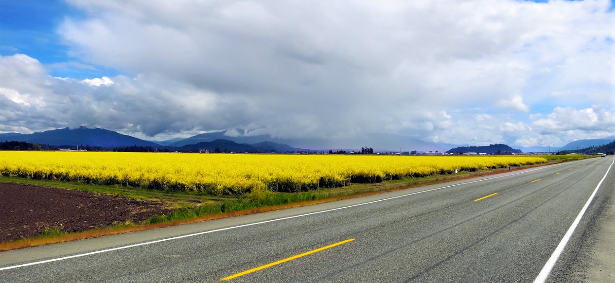 |
| Canola field on the way to Colville, WA |
 |
| The beginning of poppy season by the Spokane River |
 |
Their
flamboyant beauty |
No comments:
Post a Comment
We are always happy to hear from you but at times it may take a while to get a reply - all depends if we have access to the internet.