Interest lasts longer than happiness.
Georgia O’Keeffe
 |
Old Ford Hot Rod, Bonneville Salt Flats
|
Because of the fires, I couldn’t enter Glacier National Park from the northern entrance; I had to use the east entrance. I wanted to cross the park toward Washington but had to detour south via Idaho, again, due to fire and smoke, closing roads, campsites, and access to good views of the traversed sceneries.
Fall
is also approaching quickly. Time to be
further south to stay warm.
Glacier National Park
Glacier National Park
 |
Mount Clemens
near Logan Pass
Glacier National Park
As far west as I could
get within the park, due to fires
Had to turn around and
head south into Idaho
|
Every
glacier in the park is shrinking. The
park had over 100 glaciers when it was established in 1910. By 1966, 35 remained. In 2015, only 26 (ranging in sizes from 411
to 26 acres) met the size criterion to be designated a glacier. ALL have receded since 1966.
Melting
glaciers are just one of earth’s alerts.
As the temperature rises, the treeline is rising with it. As the treeline moves up, alpine meadows are
lost. Species that depend on these
meadows for food or protection from predators are increasingly threatened. Some animals, like the ptarmigan, have
already migrated farther up the mountain.
As the treeline continues to rise, where can they go when even these
areas become inhospitable? Not all can
travel farther north rather than upward…
 |
Fire past Hidden Lake near
Hidden Creek
Glacier National Park
|
 |
Mount Clemens,
from lush green to bare rocks
From summer-like to
winter-like
|
 |
More Mount Clemens
Last time I was in the
park was in June 2017 with Mike
Many more pictures of the
park in this previous post
|
 |
Three white mountain
goats (2 adults, one small)
Glacier National Park
|
Detour
south of Glacier National Park into Idaho
 |
Lost River Motel, Arco,
Idaho
With a welcoming Elvis,
the small Yorkie/Chihuahua
Keeping it colorful in
the face of windy and dreary conditions
An Airbnb where each room
is colored and decorated with a different theme
Animal prints of all
kinds were found in the room I rented
|
 |
Arco City Office and
Recreation Hall
First City in the World
to be lit by Atomic Power
Although temporary, it
paved the way
July 1955
|
Arco,
with a population of about 1,000, is the largest city in Butte County,
Idaho. Looking out over the flat expense
on my way here, it is understandable why it has been used for nuclear reactor
experimentation and development. Any
slip-ups would render uninhabitable a plain already voided of plants or
towns.
The
Idaho National Engineering Laboratory is 900 square miles and is closed to the
public. Since 1949, nuclear reactors –
over 50 of them – have been built on this plain, more than anywhere else in the
world.
In
1961, a reactor was destroyed due to operator error, causing the death of three
personnel present. It was the world’s
first, and US’s only, fatal reactor accident.
It
is easy to feel a sense of desolation in this place. There is very little vegetation after eight
volcanic eruptions between 15,000 and 2,000 years ago. With an average of +/- 2,000 years between
eruptions, we are nearly due for the next one.
Some of the vegetation is located within ‘Kipukas’;
islands/pockets of natural vegetation spared and sheltered by lava flows. These islands/pockets show scientists what
native plant communities looked like before grazing livestock and non-native
plants changed them. They offer fabulous
baseline data to help protect and restore native vegetation.
Islands
of cinder cones and sagebrush are scattered around. Life barely clinging at the edges.
The
park is also considered the largest remaining pool of natural nighttime
darkness in the US. I can attest
to the fact that there is not a lot of artificial light tainting the skies
here.
 |
Craters of the Moon National
Monument and Preserve
|
 |
Lunarscape – very stark
Tallest cone on the left:
Inferno Cone
Very windy area, so windy
in fact it alters the shape of the
volcanic cones, not so symmetrical,
more to one side
|
 |
Few trees left, so windy
and dry
They also tend to
lean to one side |
 |
If it weren’t for a narrow-paved
walkway
It would be very tedious
to get around |
 |
| Interesting dark, complex, crumpled lava patterns |
 |
Indian Tunnel
entrance (lava tube)
30’ high, 50’ wide, 800’
long
|
 |
| Stone Rings |
Indian
Tunnel named for stone rings that lie near the path to this large lava
tube. The Shoshones and other tribes
left behind stone structures at various locations throughout the national
monument. Archeologists believe that
some of these ancient stone structures may have had ceremonial significance for
native people, but their precise function remains a mystery. The Shoshones made use of lava caves for
shelter and as a water source during their travels through the lava lands.
 |
Inside Indian Tunnel
Collapsed roof, helping
light the way
|
 |
Survival of the fittest
in Devil’s Orchard
Since the last eruption
2,000 years ago
|
 |
Devil’s Orchard
Not many make it
|
From
pitch black lava to blindingly white salt – Craters of the Moon in Idaho to
Bonneville Salt Flats in Utah.
 |
Entrance to the Bonneville
Salt Flats Recreation Area
|
Not
sure how many years the salt flats have left.
The salt layer is quickly disappearing.
What used to be feet-thick is now merely inches-thick. Racing here may become a thing of the
past. The causes for the thinning sadly
have to do with various human activities.
What is the future going to be like?
It’s hard to say but when I was there, many of the races were cancelled
or conditions were too dangerous to reach record speeds. A disappearing act…. The white salt flats slowly turning to muddy
pits.
 |
| Hot Rod, Bonneville Salt Flats |
 |
My favorite, old car with
matching homemade trailer
Notice small mirror, soap
holder and shower at back
Seat, hatchet, saw and
small shelf on the side.
Top opens into a bed
|
 |
Another old salty on what
is left of the salt flats
Salt may be the only
thing holding these rusty cars together…
Took three hard pressure
washes to get most salt off my vehicle
after my visit here.
|
 |
A Canadian racing team with
a sense of humor
|
 |
Can’t forget the
flamingoes
|
 |
Believe it or not racing
can be seen along the horizon somewhere, somehow
Without radios to hear
what is happening or binoculars to see that far
one is more inclined to
speak with the riders and see the cars on display in the pits
The races are just the
icing on the cake
So many interesting
stories of this dying talent
|
 |
Buzzard Racing Team
1927 Model-T Ford with S-3
Desoto Engine
Average rider is between
60 and 80 years of age
Very few newcomers in
this field
Too expensive and it
takes a long time to get good at it.
Who, anymore, has the
patience for it?
|
Onward
to the Four Corners area
 |
Potash Road
on the way to Poison Spider Trail
Colorado river on one
side, these sheer cliffs on the other
Near Moab, Utah
|
 |
Private Potash Pond
bright blue rimmed with white
Dazzling colors in an
otherwise drab desert
|
 |
As seen from the air by www.amusingplanet.com
I walked from the very
bottom of this photo to the far right where
I took the picture above
through chain link fencing
So dry and sunny here,
best place for rapid evaporation
|
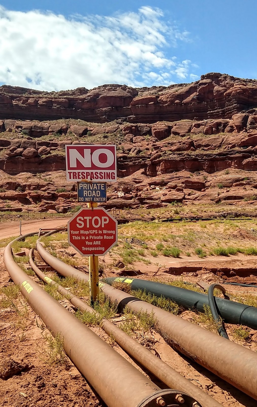 |
Many people must make
this mistake:
STOP
Your Map/GPS is Wrong
This is a Private Road
You ARE Trespassing
So, I went the other way
|
Capitol
Reef National Park
In Wayne County, UT –
hence once called Wayne Wonderland or the Land of Sleeping
Rainbow because of the contrasting multi-colored leaning sandstones
surrounded by green river bands and arid desert vegetation all folded under
deep blue skies.
Now named from the great white rock formation which resembles the US Capitol building and from the sheer cliffs that presented a barrier (reef) to early travelers. This ‘reef’ is called the Waterpocket Fold and is 100 miles (160 km) long. It seemed so impenetrable that it was the very last territory to be charted in the contiguous 48 states!
Now named from the great white rock formation which resembles the US Capitol building and from the sheer cliffs that presented a barrier (reef) to early travelers. This ‘reef’ is called the Waterpocket Fold and is 100 miles (160 km) long. It seemed so impenetrable that it was the very last territory to be charted in the contiguous 48 states!
 |
Gifford Homestead in
Fruita settlement, Capitol Reef National Park
Barn and orchards from
old Mormon establishment
Allowed to pick fruits
for free while in season
as long as you stay inside
the 3,000-tree orchard
If you want to bring
fruits/nuts out of the orchard you pay
a small fee per pound
(was $1/# when I was there).
I don’t know of any other
parks where this is available.
Enjoy!
|
Fruita was a modest Mormon community
established in the 1880’s. It never consisted
of more than 10 families and was a safe haven for polygamists. It is now part
of Capitol Reef National Park. In 1896
the one room school also served as church and meeting place. Kids only went to school once farming needs
were met, roughly from November to April only.
In their orchards they grew almonds, pecans, apples, pears, peaches,
apricots, quince, cherries, and plums.
There are so many fruits rotting on the grounds that local deer get sick
from eating so much sugar instead of their regular grass-based diet. When I visited the apricot season had just
finished, its perfume still hanging in the air.
Apples were not quite ripe however so I didn’t get to pick anything –
next time…
‘It is a maze of cliffs and terraces… red and white domes, rock
platforms gashed with profound canyons, burning plains barren even of sage –
all glowing with bright colors and flooded with blazing sunlight…. It is the
extreme of desolation, the blankest solitude, a superlative desert.’
Clarence E. Dutton, geologist, 1880
To
think that when this beautiful area was formed, this continent was along the
equator, where Northern South America is today!
 |
Fremont Culture
petroglyphs
Named after Fremont River
Valley
aka Hisatsimon
(people of long ago), 300-1300 CE
They were potters, rock
mason, farmers, hunters, gatherers
Precursors of the Zuni,
Hopi and Paiute people
|
The Fremont people were
contemporaries of the Ancestral Puebloans (Anasazi) of the Four Corners area. Anthropomorphic figures normally had
trapezoidal shaped bodies with arms, legs and fingers. The figures were often richly
decorated with headdresses, earrings, necklaces, clothing and facial
expressions. A wide variety of zoomorphic figures include bighorn sheep, deer,
dogs, birds, snakes and lizards. Abstract designs, geometric shapes and handprints
are also common. The ones represented
above are located far from foot traffic, so my picture is not very clear, but
these figures are approximately six-feet tall.
 |
Small arches being
created everywhere you look
Following streambed, you
see the sculpted heart of Capitol Reef
Footsteps echoing between
the towering sandstones escarpments
surround you everywhere
you go in these canyons
|
 |
Or mushroom rocks
guarding the path
Cohab Canyon Trail
|
 |
| Or ooze-like colorful smooth rock creations |
 |
| Named ‘The Castle’, for obvious reason |
 |
Hickman Bridge
Massive 133 feet (41
meters) span
Bridge rather than arch
because it is over a stream/river
|
 |
Reminiscent of what I saw
in Namibia’s Spitzkoppe
|
 |
Bush Cassidy’s Arch
Named after the notorious
outlaw and train robber who was
thought to have hidden in
these canyons
At 140-foot-tall, it sits
400 feet above Grand Wash Road that leads to it…
While you see most arches
from below, this one is approached from above!
|
 |
Behunin’s Cabin,
1882
Home of Tabitha Jane and Elijah
Behunin
They had 13 kids although
we don’t know how many
they had while they lived
here for only a couple of years
Repeated floods destroyed
their crops, they moved elsewhere
Illustration of hardship
of early settlers looking for religious freedom
Living in rugged, remote,
unforgiving areas
|
Arches
National Park
 |
Arches National Park
Just because I was
passing by
But I regretted it.
I was lucky to have seen
it in the late 1980s without the crowd,
the trash, the
graffiti. Better remembered the old way.
|
It
is only possible for these arches to form thanks to very little rain (less than
10 inches a year), the right type of stones (Navajo and Entrada sandstones)
sitting on a moving bed of salt thousands of feet thick, as well as no
destructive earthquakes to eliminate or damage the fragile arches. With some 2,000 arches (defined as more than
3-foot span), the park contains the highest density of natural arches in the
world.
Edward
Abbey (one of Mike’s favorite authors – and mine as well) was a park ranger
here (1956-57), where he kept journals that became his famous book, Desert
Solitaire (quality of the writing compared to that of Thoreau’s
Walden). The first book I read with
Mike while we were camping in the area 30 years ago. His descriptions of the desert made me
appreciate the landscape on a much deeper level.
Wilderness is not a luxury but a necessity of the
human spirit,
and as vital to our lives as water and good bread.
A
civilization which destroys what little remains of the wild, the spare,
the original, is cutting itself off from its
origins and
betraying the principle of civilization itself.
Edward Abbey
Edward Abbey
Wilderness. The word itself is music.
Edward Abbey
Edward Abbey
Belief in the supernatural reflects a failure of
the imagination.
Edward Abbey
 |
More delightful sandstone
eccentricities
From grey (Navajo
sandstone) to salmon (Entrada sandstone)
|
 |
| Fins – the mothers of arches |
 |
Park Avenue,
geological ‘skyscrapers’
Like tall buildings
lining a street
|
 |
Newspaper Rock
Recording 2,000 years of
history from 700 BCE to 1300 CE
Designed in desert
varnish, which would eventually recover everything over time
|
 |
| Needles, part of Canyonlands |
Came to Needles for my very first camping trip with my then new boyfriend
30 years ago. He passed away a couple of years ago and coming back here brought
back a lot of good, though sad, memories. Then, we were nearly the only ones on
mountain bikes – it hadn’t been discovered yet. We lucked out enough to watch a
full eclipse of the moon on one side, while on the other side, there was a
thunderstorm with flashfloods filling the canyons with red silty water. Then we
encountered dead animals that had gotten caught in the flash flood and a pink 4x4
tour group that didn’t make Elephant Hill and went tumbling down. My husband, a
medic, helped with the helicopter rescue. The forces of nature are tremendous…
Biking after the flashfloods was challenging, encountering a lot of hidden quicksand…
This time it was very hot and quiet. I hadn’t planned anything specific and when I looked at a historical calendar of full eclipses of the moon, I happened to be in the park exactly 30 years later to the day!!! What a nice ‘coincidence’?
This time it was very hot and quiet. I hadn’t planned anything specific and when I looked at a historical calendar of full eclipses of the moon, I happened to be in the park exactly 30 years later to the day!!! What a nice ‘coincidence’?
 |
Unbeknownst to me I
visited again exactly 30 years to the day
My first camping trip
with Mike was here on August 17th, 1989
|
 |
Cave Spring Trail
Overhang ‘cave’ where
cowboys camped while
ranching cattle (1890 –
1975)
Thanks to its natural protection
and year-round water source
Has seen 1,000 years of
human use (natives prior to cowboys)
|
Amazing that there are
still artefacts left from an era when true pioneering cattlemen worked/lived
here (late 1800’s through 1975, end of cattle ranching within park). It is
difficult to fathom that by 1926, there were 10,000 head of cattle over 1.8M
acres. To succeed, ranchers needed 200 acres per cow in this type of
environment – a huge distance to monitor well.
Cave Spring was an isolated outdoor camp for cowboys because of its reliable source of water, rainwater percolating through layers of porous sandstone = seep.
Today, Heidi Redd runs the 5,200-acre Dugout Ranch bought by The Nature Conservancy in 1997 to save this iconic landscape from development and to help with research on the interactive effects of grazing, and other types of land use, as well as climate change.
Well,
after more than 14,000 miles (22,500 km) it is time to let my faithful pickup
rest a bit. I am now enjoying the land
of enchantment, New Mexico. I can see
why Georgia O’Keefe chose such a place for inspiration, collecting bleached
bones, rocks and memories. What a beautiful
area, colorful yet stark, bold yet cautious, vibrant yet serene, full of simplicity
of line and form, centering around light and space… Great for reflection, contemplation and
appreciation of nature and life.
 |
Black Mesa,
1930
|
If I could paint the flower exactly as I see it no
one would see what I see because I would paint it small like the flower is
small. So I said to myself - I'll paint
what I see - what the flower is to me but I'll paint it big and they will be
surprised into taking time to look at it - I will make even busy New Yorkers
take time to see what I see of flowers.
Georgia O’Keeffe
 |
| Oriental Poppies, 1927 |
More
on the marvelous and inspiring sights of New Mexico in upcoming post.
No comments:
Post a Comment
We are always happy to hear from you but at times it may take a while to get a reply - all depends if we have access to the internet.