If we don’t have it, you don’t need it
Storefront in a remote area
 |
Mount
Adams in the early morning sun, another
majestic mountain
Although
it has not erupted for over 1,000 years, it is not considered extinct
Less
than 520,000 years old – First ascent, like Mt. Shasta, in 1854
Second
largest volcano after Mt Shasta in California
|
The Pacific Crest Trail crosses the Columbia River here (free to pedestrians). The Bridge of the Gods is also the lowest elevation on the entire trail.
Following his trans-Atlantic flight,
Colonel Charles Lindbergh in 1927, flew the Spirit of St. Louis up the Columbia
Gorge from Portland, low over the new bridge and then made a 180 degree
turn and flew under the bridge, back to the Portland airport.
 |
Artist: Paul A.
Lanquist (PAL)
|
 |
Silver
Falls, Mt Rainier
|
 |
Stonehenge
Memorial, 1929
Cement
replica to size, by Samuel Hill
|
Samuel Hill, the famous road baron and patron of this region, established the Maryhill townsite with post office, hotel, general store, and a beautiful, though unfinished, French mansion now turned into The Maryhill Museum of Art. His tomb is 40 yards away, on the opposite side of the Stonehenge Memorial. He was a Quaker Pacifist that said, after visiting the ‘true’ Stonehenge: ‘After all our civilization, the flower of humanity still is being sacrificed to the god of war on fields of battle.’ From that inspiration came this monument (today however, the sacrifice legend is generally discredited, current belief is that Stonehenge was a device used by astronomers to measure time).
What used to be a very desolate area is now being surrounded by newly planted vineyards. Sam Hill would’ve loved to see agriculture finally taking hold in the area.
 |
Maryhill Museum of Art
French mansion (L) mixed with
modern addition (R)
Sits on the Ice Age Floods National
Geologic Trail (more on that below)
|
 |
Brushing, Mike Suri, 2009
Outdoor sculpture garden at the
Maryhill Museum
Often windy around here – this
piece seems to fit the landscape
|
Of the Historic Columbia River Highway (HCRH), the King of Roads, Poetry in Stones:
‘On
starting the surveys, our first business was to find the beauty spots,
or
those points where the most beautiful things along
the line might be seen in
the best advantage, and if possible,
to locate the road in such a way as to
reach them.’
Samuel Lancaster, HCRH Engineer
Samuel Lancaster, HCRH Engineer
The Historic Columbia River Highway is a tale of visionaries, civic leaders, skilled engineers and talented craftsmen. And they did it with elegance, reconciling the beauty of nature with the needs of civilization.
Together with Engineer Samuel Lancaster, lawyer, ‘good roads’ advocate and entrepreneur, Sam Hill envisioned more than a route through the Columbia River Gorge. He inspired the construction of a highway to rival the great roads of Europe.
In 1986, the Columbia River Gorge became the first and only National Scenic Area in the United States.
Over the years, this grand road was replaced by a modern highway and many of its treasures lost. Tunnels were filled and bridges destroyed, but thanks to the efforts of many dedicated supporters, the Highway is being restored. Today, you can still drive segments of the Historic Columbia River Highway and walk or bicycle along once-abandoned sections that have been restored as the Historic Columbia River Highway State Trail.
 |
Hanford REACH Interpretive Center, Richland, WA
Learning about the Manhattan
Project as well as the Big Floods
|
Shortly after the construction of the Bonneville Dam (previous post), construction of the Grand Coulee Dam began. In 1941 when its construction was completed, it was hailed as the Eighth Wonder of the World. The dam contains nearly 12 million cubic yards of concrete, making it one of the largest concrete structures in the world.
Building the dam provided jobs for thousands of people. No other public works project had a greater impact on the development of the Pacific Northwest. The dam was the crown jewel of President Roosevelt’s National Public Works Projects. Today Grand Coulee Dam is the largest energy producer in North America, producing as much power as six nuclear plants, with zero emission. It also created the 151-mile-long Lake Roosevelt, which irrigated 670,000 acres with 1,339 miles of irrigation canals and 3,500 miles of drains and waterways.
In 1943, its electricity was used for plutonium production at Hanford, which was part of the top-secret Manhattan Project. The demand for power at that project was so great that two generators originally meant for the Shasta Dam were installed at Grand Coulee to speed-up the installation schedule. Arguably the most important component of the Hanford Engineering Works (HEW), the Columbia, offered a near limitless supply of the clean, cold water that was necessary to maintain the reactors cool.
Five main criteria for site selection (Hanford was chosen after Oak Ridge and Los Alamos) were:
1)
12 x 16 miles of manufacturing area.
2) 10 miles from nearest public highway or railroad.
2) 10 miles from nearest public highway or railroad.
3)
20 miles from nearest town of 1,000 or more.
4)
Available 5,000 gallons/minute of water.
5) Access to electrical supply of 100,000 kw
5) Access to electrical supply of 100,000 kw
Hanford Construction Camp
The folks who lived here were called Boomers on Wheels (Ted Van Arsdol). They lived in tiny trailers due to the severe housing shortage. There were 3,600 trailer spaces. Each trailer was 147 sqft and could accommodate an average of 3.7 people and didn’t have a bathroom, only a kitchen, sitting area and bedroom. They nearly provided the equivalent of ‘normal’ family life since barracks were gender specific. Combination laundry/bathhouse building was provided for each 30 trailers. They were the Nerve Centers where small neighborhood gatherings happened. Supper parties were held there since the trailers were too small for entertaining.
People made many homey touches to the trailer spaces to make them uniquely their own. White picket fences and white painted rocks were used to establish their territory. Wooden framed canopies were provided to help cut the heat, and residents were given grass seeds and hoses for landscaping.
To that, add 131 men’s barracks, 64 women’s barracks, 8 mess halls and separate beer halls for men and women. Additionally, you could find an auditorium, a theater, a butcher shop, a grocery store, a Sears outlet, a hospital, a post office, and a bus system. Over time they eventually added banks, watering holes, churches, a baseball field, and a swimming pool.
Nearly overnight, it became the fourth largest city in Washington and the largest voting district in the USA in 1944. It had the largest general delivery post office in the world.
There were only about 6,700 people living along the 30-mile stretch of the Columbia River between White Bluffs and Hover. A year later the construction camp at Hanford was home to 51,000 people. In spring 1945, the camp was closed as the bulk of the construction was completed. In less than two years, 1,200 buildings, most living quarters of some sort, were built to accommodate 137,000 people who passed through the area. People didn’t stay at the camp very long.
Heat, desolation, wind, always the wind – in excess of 30 mph gusting to 70 mph + sand working its way into everything. Called ‘termination winds’ as folks quit by the thousands after a good wind/sandstorm…
Interesting facts:
One Uranium pellet is equal to:
- 149 gallons of oil, or
- 17 million thermal units of natural gas, or
- 1,780 pounds of coal
- Four pellets can power a typical home for one year.
- Columbia Generating Station’s reactor = 28 million pellets, third largest producer of electricity in Washington behind Grand Coulee and Chief Joseph dams.
- Only one woman, Leona Marshall Libby worked at Hanford; she solved the riddle of the B reactor’s xenon poisoning.
- $2B Manhattan Project had been called the largest organized construction project since the pyramids.
- The 51-mile Hanford Reach is the last free-flowing non-tidal stretch of the Columbia in the USA.
- Hanford Reach is the last remaining expanses of shrub-steppe habitat
While no espionage is known to have occurred at Hanford during the war, the design of the first Soviet’s nuclear reactor closely resembled Hanford’s test reactor, a coincidence that, at the very least suggest some success on the part of Russian spies. Richard Rhodes
It was a very raucous place where security forces spent as much time fighting gambling, prostitution and rampant drunkenness as they did, looking for spies.
Nearby Richland (Tri-Cities, WA)
Richland is where people continued living after Hanford was dismantled. Where counter-intelligence agents kept tabs on residents, background investigations were conducted, local police had copies of keys for every house in town, taking photos required the approval of area managers, phone lines were tapped for evidence of loose talk and outgoing mail was read. Even the phonebook was stamped ‘CLASSIFIED’. Only HEW employees and their families could live here, carefully cultivating an image of normalcy.
‘Nuclear physics is now a mature science with an associated complex technology’ Philip Abelson, UC Berkley, ‘But in the 1930’s, it was an amateur sport…’ Today it’s hard to grasp exactly how theoretical nuclear physics was at the time of the Manhattan Project, a time when some of the 20th century’s greatest scientific minds helped end a brutal war, and, in the process, changed the world forever.
 |
| Part of the National Park Service |
 |
Ice Age
Floods National Trail established in 2009
|
The Ice Age Floods Geologic Trail, Montana to Washington,
Oregon and Idaho
During the last ice age, about 18,000 to 12,000
years ago, an immense lake covered the western edge of Montana, Lake Missoula.
The lake water was trapped by a glacier along the Idaho panhandle that acted as
a dam. When the dam melted, the entire lake, as much water as in Lake Ontario
and Erie combined (3,000 square miles), surged across Idaho, Oregon and
Washington to the sea.
The Ice Age Floods carved a
huge, bare, basalt channels and dry falls, stranded massive boulders, deposited
gravel bars whose fantastic scale dwarfs their modern counterparts, scoured channels, back-flushed rivers and ponded-in temporary
lakes.
These mega floods gouged out basins along the
Columbia River, deposited 200-ton boulders throughout the area and wore out the
territory now known as the Channeled Scablands.
The unflattering term sometimes is applied to rough or barren regions
with little or no economic potential, especially for agriculture.
 |
NASA base image shows
eastern WA Channeled Scabland from space.
Major scabland tracts
are identified:
1-Moses Coulee, 2-Grand
Coulee, 3-Telford-Crab, 4-Cheney-Palouse.
|
The Channeled Scablands extend from the area around Spokane, west to the
Columbia River
near Vantage and southwest to the Snake
River near Pasco. They are known as the Channeled Scablands because they are
crisscrossed by long channels cut into the bedrock, called coulees.
 |
Scabland from the Telford-Crab
Coulee area (#3 above)
|
I have driven through the Channeled Scablands innumerable times over the last 25 years, yet I never knew how they were formed. The force of nature is unsurpassed.
- #1 in US = apples, sweet cherries, pears, concord grapes, red raspberries, carrots for processing, hops, spearmint and peppermint oil, wrinkled seed peas.
- #2 in US = apricots, asparagus, grapes, potatoes, green peas, corn for processing, onions, nectarines. Also #2 for diversity of crops, more than 300
- #3 in US = export of food and agricultural products at $9B/year. Top exports: wheat, corn, apples, processed potatoes, cherries, milk.
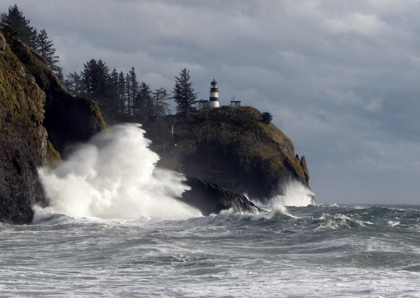 |
Cape Disappointment Lighthouse (for boats coming from the south)
There is also the North Head
Lighthouse (for boats coming from the north)
Difference between the two,
southern one has black and white stripes
|
 |
A large cargo ship leaving the
mighty Columbia
Calm day but you still need a bar
pilot to guide you
|
 |
Looking
towards Oregon from Cape Disappointment, WA
|
 |
Interesting
church in nearby Oysterville
|
 |
Don’t you just love this barn? So pristine yet old…
|
 |
Rugged
Cape Flattery, view to the south
Oldest
permanently named feature in Washington State
Named
by James Cook in 1778
Northwesternmost
point in contiguous USA
Where
the Strait of Juan de Fuca joins the Pacific Ocean
|

 |
Makah
meeting place near Hobuck Beach
Olympic
Peninsula
|
 |
Makah
carving details
|
 |
| People totems outside Makah Museum |
Welcome from the Makah Tribe. We call ourselves ‘Kwih-dich-chuh-ahtx’ or ‘people who live by the rocks and seagulls’. The name Makah, which was given to us by our neighboring tribes, means ‘generous with food’. We have lived at the most northwestern point in what is now the contiguous United States since the beginning of time.
For thousands of years we have hunted whales and seals and fished in the great waters which border our home. Throughout our history, the great Western Red Cedar tree has provided the material from which we have housed and clothed ourselves. Cedar has also provided the means by which we have fed ourselves by providing material for canoes and tools.
In 1970 tidal erosion uncovered an ancient whaling village at Ozette, parts of which had been covered by a mud slide hundreds of years ago. The subsequent artifacts which were found have now classified Ozette as one the most significant archaeological discoveries ever made in North America!
Cape Alava, Ozette Archeological Site
The village of Ozette was located 15 miles south of Neah Bay and served as a year-round home for Makahs until the early 20th-century.
In the winter of 1969-1970 a storm caused the bank at the Ozette village location to collapse, exposing hundreds of perfectly preserved wooden artifacts! A hiker contacted the Makah Tribe, then the Tribe phoned Washington State University, and in April 1970, some two months after the storm, excavation of the Ozette Archaeological Site began.
Makah’s oral history told of a ‘great slide’ which buried a portion of Ozette long ago. In collaboration with the Makah Tribe, archaeologists proved this oral history correct. Radiocarbon dates demonstrated that a slide around the year 1750 buried six longhouses and their contents, locking the pre-contact wooden and wood-based artifacts in a blanket of mud. The eleven-year excavation produced over 55,000 artifacts, which the Tribe kept on the reservation.
The Makah museum came about from the Tribe’s desire to curate and interpret this outstanding and unique collection. A full-sized longhouse has been constructed complete with bench planks, room dividers, and real smoked fish! The uneven floor is exactly as it was in the old longhouse excavated at Ozette.
The exhibits take one through the seasons of the year and the types of activities that were being practiced in pre-contact times. Many of these activities still make up the annual cycles of everyday Makah life centuries later!
 |
Interesting
design in the sand
Yep
– it’s upside down but I like it that way, it gets your attention
|
 |
Olympic Peninsula
Makah Bay
|
 |
Beach-combing
find…
|
 |
Olympic
Peninsula
Moss
on giant tree by Lake Crescent
|
 |
| So wet – even mailboxes are covered with moss |
 |
Hanging
moss in Hall of Mosses of the Hoh Rain Forest
Like
walking through a living green cathedral
Where
banana slugs can reach 10” long!
|
Lush beards of clubmoss are attached to boughs but feed only on air and light. The rainforest atmosphere supplies enough moisture and wind-borne nutrients. Certain trees like these bigleaf maples support denser clusters of airplants or epiphytes (lichens and hanging mosses), depending on different types of limbs, available sunlight, and relative dampness.
 |
Largest
Sitka spruce in Quinault Rainforest
Average
rainfall 12’ per year
58’11”
circumference, 191’ tall
About
1,000 years old
|
 |
Olympic Peninsula
|
‘Water is the driving force of all nature.’
Leonardo da Vinci
No comments:
Post a Comment
We are always happy to hear from you but at times it may take a while to get a reply - all depends if we have access to the internet.